TECHNICAL/CONDITIONAL REQUIREMENT
Table of difficulty
The table gives you an overview of the technical and physical requirements of our treks. If you have any questions or uncertainties, we will be happy to advise you.

THE DIFFICULTY SCALES BRIEFLY EXPLAINED
The SAC hiking scale
The hiking scale was introduced by the SAC, the Swiss Alpine Club. "T" stands for trekking. The scale starts with the easiest grade T1 and goes up to the most difficult grade T6. The scale is an important tool for planning tours and gives you an overview of what technical difficulties to expect on a route and what requirements are necessary for a tour.
In the range from T1 to T2, the trails are usually well visible and developed. The terrain is little to moderately steep, but can already have steeper passages. These are usually well secured. Some surefootedness as well as basic knowledge of orientation are required. The marking of the hiking trails is yellow.
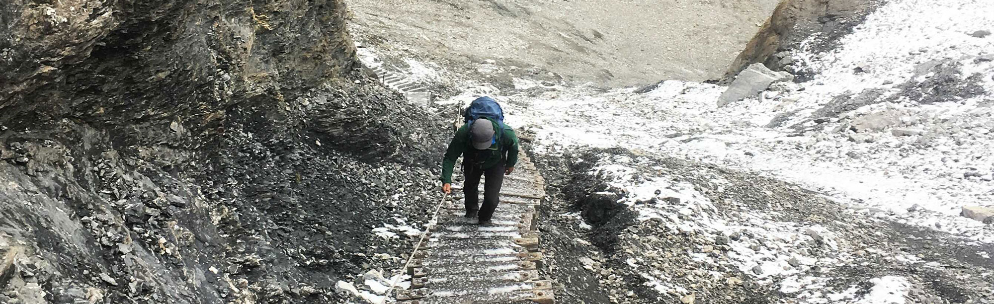
From T2 to T3 hiking trails are also marked red-white-red. These are mountain trails. The course of the route is not always obvious throughout. The terrain can be steep with exposed passages, some of which are secured with chains or ropes. There may be a risk of falling. Surefootedness, average orientation skills and experience of hiking are important.
From T4 the hiking trails are marked blue-white-blue. These are alpine hiking trails. Often there are only trail tracks, which lead through impassable and not secured terrain, which is partly very steep and exposed. There is an immediate danger of falling. Therefore, very good surefootedness, orientation and, above all, a lot of experience is necessary.
Even if a route is divided into a grade, the actual technical difficulty can vary depending on the conditions. For example, when the terrain is dry, trails are often easier to walk than when the soil or rock are wet and slippery. Therefore, it is important to plan hikes carefully, to take into account external factors such as weather and snow conditions, and to properly assess your own abilities.
")
The snowshoe hiking scale
Based on the hiking scale, there is the SAC difficulty rating for snowshoe tours. This starts at WT1, the easiest rating, and ends at WT6, the most challenging grade. "WT" stands for winter trekking.
It is important to know that snowshoe routes lead through terrain that is not secured. There is a risk of avalanches depending on the steepness and conditions. In addition, only certain snowshoe trails are marked. Often, however, you have to navigate yourself. Therefore, knowledge in the use of navigation aids is crucial.
WT1 routes lead through generally flat terrain. The danger of avalanches, but also of slipping is very low.
Routes between WT2 and WT3 lead through terrain that is less than 30° steep. However, since steeper slopes are present in the vicinity of the route, basic knowledge in assessing the avalanche situation is necessary. However, the danger of slipping or falling remains low.
From WT4, the terrain becomes increasingly steep to very steep. Accordingly, good knowledge in assessing the avalanche situation is necessary as well as experience of alpine tours. There is a danger of slipping and in exposed places also of falling. Routes can also lead over the glacier.
The difficulty of our offers ranges from WT1 to WT3. Wearing avalanche equipment (avalanche transceiver, shovel, probe) is mandatory on all tours. A short introduction to avalanche rescue is part of every program.

The bike scale
As in hiking, the bike scale describes the technical difficulty of a trail. It starts at S0, the easiest grade, and goes up to S5, the most difficult rating.
S0 means that you are on fluid forest and meadow trails, which are well compacted and mostly flat to little steep. Mostly they are gravel paths. There are no obstacles to be expected. No special riding techniques are necessary. The trails can be ridden on road bikes, trekking bikes, gravel bikes and of course mountain bikes.
Trails rated S1, in contrast to S0, may already have smaller obstacles such as water channels or shallow roots. The trails can be somewhat steeper. Basic riding skills are therefore necessary to be able to roll over the obstacles. The trails can be ridden with trekking, gravel and mountain bikes.
From S2 to S5 there are trails that can be ridden with mountain bikes. These trails lead increasingly over rough, steep and steeper terrain and require a high degree of riding skills.
Our offers range from S0 to S1.
